01
Geospatial & Data Engineering
Connect source data to dependable spatial systems through batch and streaming pipelines, SQL, ETL/ELT, Spark, PostGIS, enterprise GIS, and automated QA/QC.
Reliable data foundations
Raleigh, North Carolina
Geospatial & Data Engineer
GeoAI · Spatial Data Systems · Cloud & Security
Trusted data systems.
Better decisions.
I build reliable, secure data and geospatial systems that transform complex information into actionable intelligence—combining data engineering, enterprise GIS, GeoAI, cloud infrastructure, and security-aware design.
Explore the GeoAI surveillance demo
My work in public-health surveillance and GIS began in 2014 supporting Ebola response in Nigeria, followed by an African Union deployment to Liberia. Since then, I’ve built a foundation in geospatial and data engineering, connecting data quality, pipelines, databases, spatial analysis, models, and maps to the decisions they need to support.
Today, I specialize in GeoAI and spatial intelligence, shaped by experience across public-health surveillance, emergency response, environmental GIS, and applied research. My growing capabilities in cloud, Linux, automation, and security strengthen how I build, monitor, and govern the systems behind that intelligence.
My ongoing contract work extends that practice into geospatial AI review and quality assurance. Separately, I developed and evaluated a synthetic geospatial benchmark under a contract program; that development has concluded. These experiences complement my GeoAI surveillance research: building analytical systems, testing evaluation benchmarks, and reviewing AI-generated geospatial reasoning.
Connect source data to dependable spatial systems through batch and streaming pipelines, SQL, ETL/ELT, Spark, PostGIS, enterprise GIS, and automated QA/QC.
Turn spatial patterns into decision support through machine learning, forecasting, spatial statistics, and explainability—grounded in public-health and emergency-response questions.
Support data-intensive workloads with AWS and Azure, Linux automation, APIs, monitoring, access controls, and privacy-aware governance. Developed through research and hands-on labs.
From source data to governed decisions.
From surveillance data management and applied GIS research to national geospatial systems, enterprise GIS, data engineering, geospatial AI evaluation, quality assurance, and benchmark development.
Independent Contractor — Geospatial Evaluation
Evaluate AI-generated geospatial analysis workflows and conduct quality-assurance reviews, focusing on methodological soundness, data provenance, spatial reasoning, data-source suitability, analytical completeness, and evidence-supported conclusions.
Professional responsibilities only. Confidential client tasks, individual evaluations, internal criteria, and platform materials are not reproduced.
Contract-program task
Developed and evaluated a synthetic geospatial benchmark for residential-location inference, grounded in surveillance field experience and modelling ambiguous place names, conflicting geographic evidence, imperfect landmark reports, and location uncertainty.
Development concluded after a registered 30-repetition pilot that did not meet all predefined advancement criteria. Implementation and experimental evidence were preserved; no further development is currently underway.
Independent portfolio project
Developed reproducible emergency-management workflows focused on building-footprint processing, spatial QA/QC, topology validation, hazard exposure, and geospatial automation.
Independent portfolio demonstration, with a corrected and validated flood-exposure rerun in October 2026. Not employment by or commissioned work for NC Emergency Management.
African Field Epidemiology Network (AFENET) · Full-time · U.S. CDC-funded
Designed and administered enterprise geospatial databases, analytical workflows, automated quality controls, and operational GIS applications supporting Liberia’s national disease surveillance, outbreak response, and emergency preparedness.
African Field Epidemiology Network (AFENET) · Contract · U.S. CDC-funded
Supported NPHIL and Liberia’s Ministry of Health through an AFENET technical assignment, connecting national COVID-19 epidemiological and location data with operational public-health intelligence.
AFENET was the contracting employer; NPHIL and the Ministry of Health were host and beneficiary institutions.
Jul 2019 - Feb 2020
Society for Environmental Conservation
Applied spatial analysis to land-use planning, environmental assessment, climate-smart agriculture, and conservation. Contributed GIS expertise to the Sustainable Landscape Rating Tool, supported participatory mapping and field-data workflows, and trained project personnel.
2016 - 2018
UN-ARCSSTE-E
Conducted applied geospatial research in Nigeria across disease risk, land suitability, and environmental modelling. Used cartography, raster processing, and spatial analysis to develop reproducible research outputs and contribute to peer-reviewed publications.
Dec 2014 - Oct 2015
African Union Commission · Liberia deployment
Seconded by the Government of Nigeria to the African Union Ebola-response mission in Liberia. Managed and validated national surveillance and contact-tracing datasets, developed GIS-supported collection tools, coordinated spatial reporting, and trained local response personnel.
Aug - Nov 2014
Rivers State Ministry of Health / Rivers State Government · Nigeria
Supported the Ebola Emergency Operations Centre with data cleaning, analysis, GIS-supported contact tracing, and operational mapping under WHO-supported technical supervision. Improved digital reporting and trained health workers in ODK and Epi Info.
 Architecture & engineering case study
An evaluated research prototype connecting governed data engineering, spatial intelligence, explainable risk classification, and authenticated decision support. Explore the architecture, implementation, and post-dissertation validation.
Retrospective research proof of concept; not validated prospective forecasting or a production surveillance service.
Developed and evaluated a synthetic geospatial benchmark for residential-location inference, including Python data-generation and validation components, controlled experiments, and reproducible workflows.
2026 · Contract-program task. Development concluded. Protected data and confidential evaluation materials are excluded.
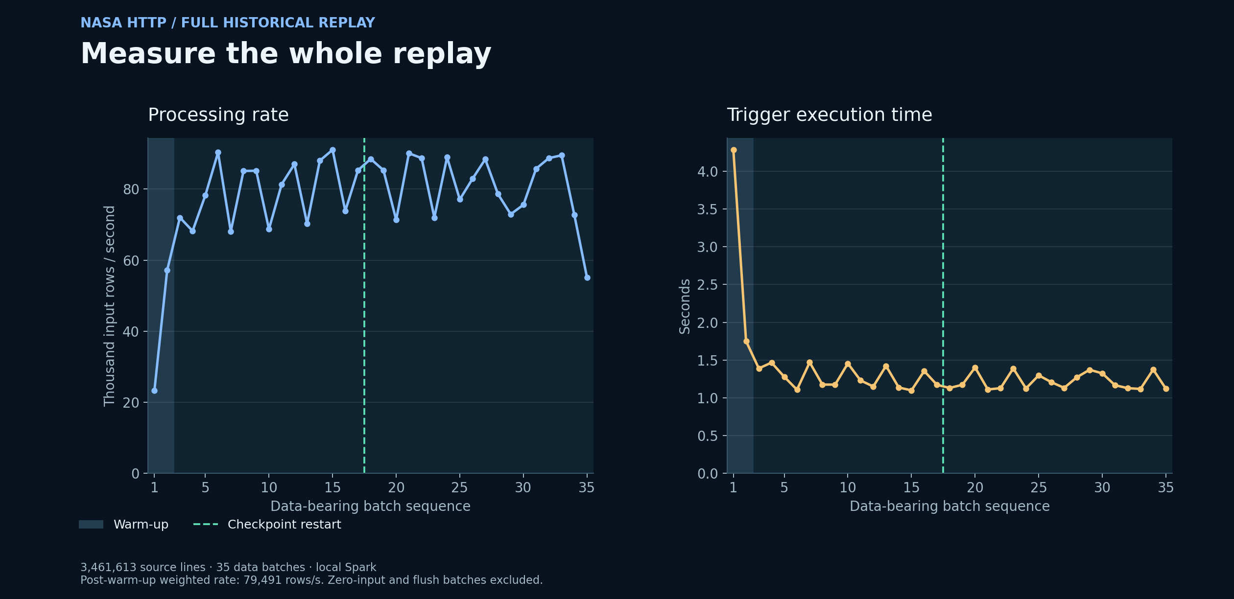 Full historical replay · Processing and recovery
A full historical NASA-log replay with durable event-time counts, complete batch metrics, and tested checkpoint recovery.
Historical NASA log replay · Event-time processing and query observability.
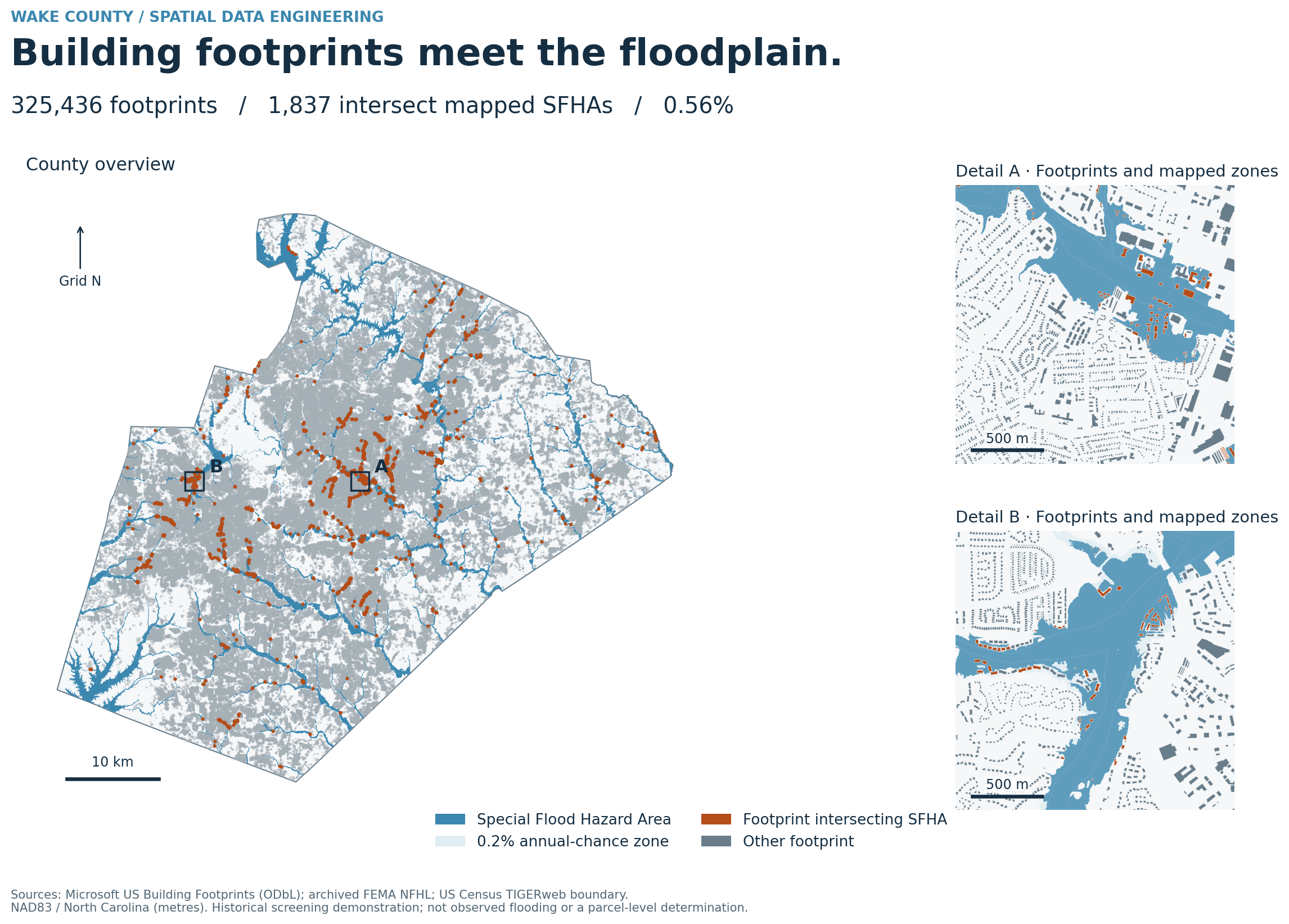 Spatial analysis · Building exposure
County-scale footprint preparation, spatial QA, and reproducible flood exposure analysis with distinct building identifiers and independently reconciled results.
Independent portfolio demonstration · Corrected flood analysis: October 2026 · Not commissioned by NCEM.
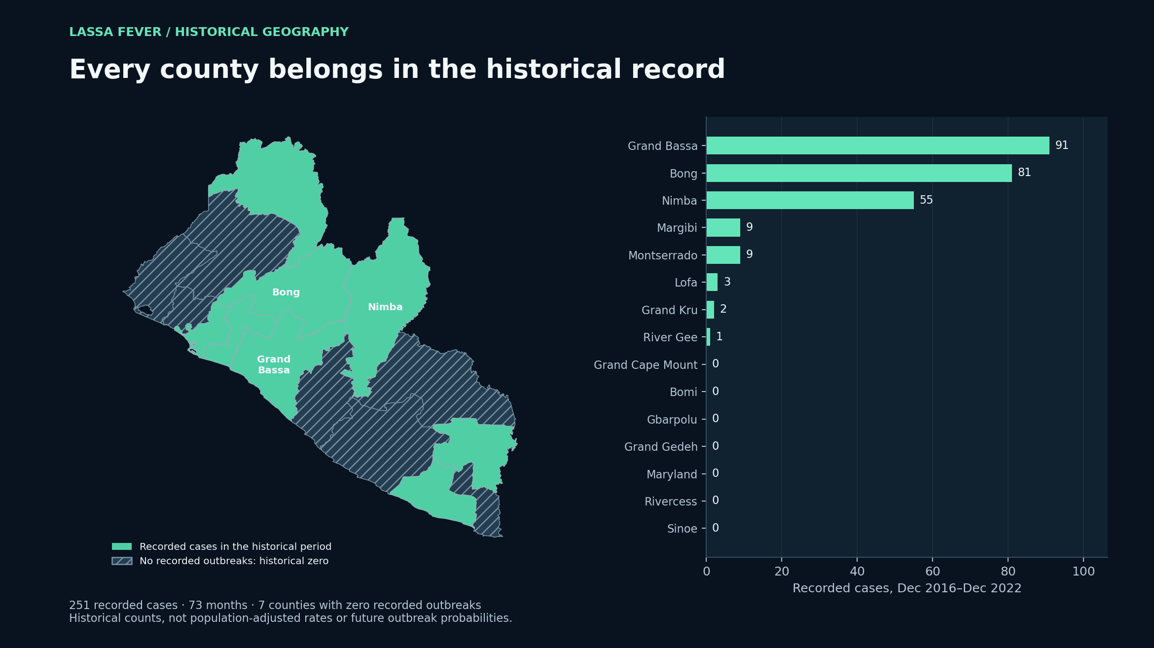 Historical surveillance coverage · All 15 counties
Surveillance data engineering, rolling-origin forecasting, and county model benchmarking across Liberia.
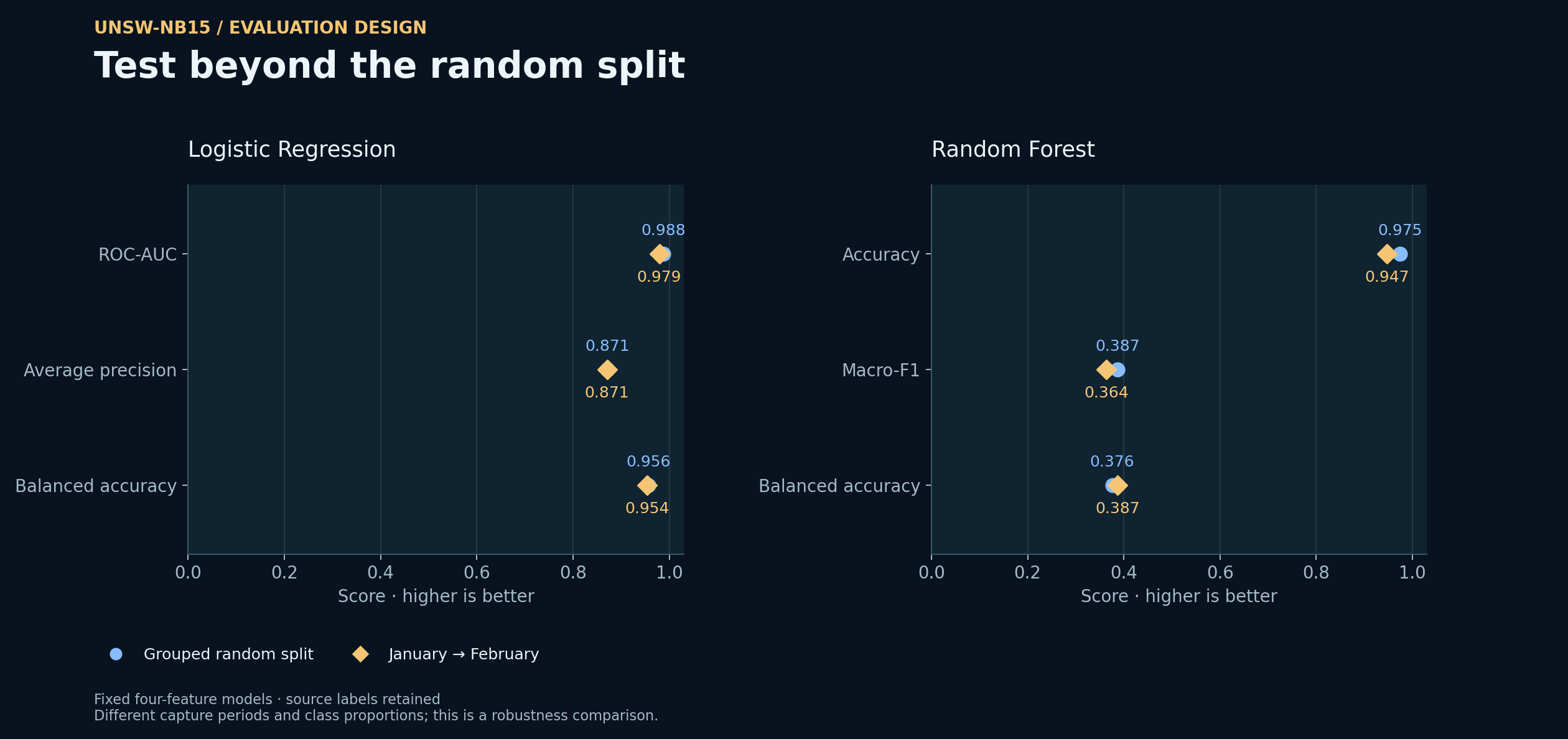 Random split vs later capture · Reproducible evaluation
Network-traffic data engineering and reproducible PySpark evaluation, from source labels to per-class detection.
HDFS ingestion · Hive exploration · Interpretable ML baselines.
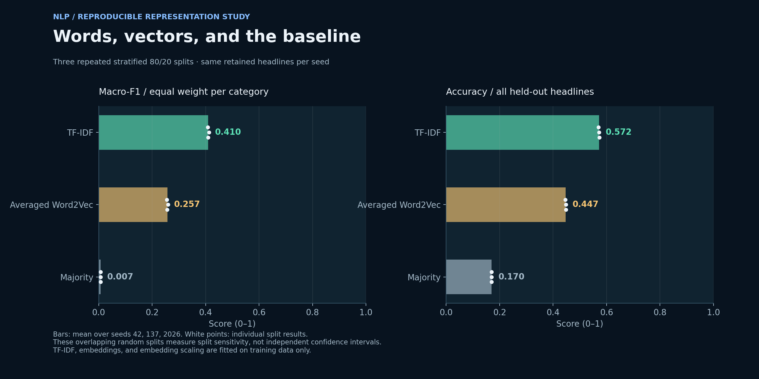 Feature representations · Classification performance
Built a reproducible text-processing workflow spanning ingestion, cleaning, TF-IDF and Word2Vec feature pipelines, classification, K-Means clustering, and held-out topic evaluation.
Text representations · Supervised evaluation · Cluster interpretation.
Four practical labs connecting host observability, cloud infrastructure, repeatable delivery and cryptographic integrity. Explore the implementation, architecture and verified evidence.
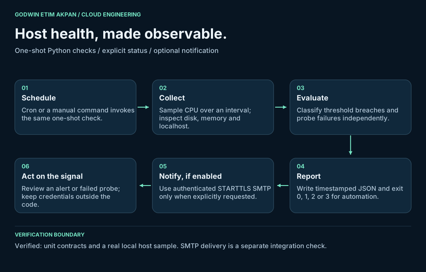
Interval-based CPU sampling, isolated probe errors, explicit exit states and optional authenticated email.
11 tests passed · Real local host alert verified.
SMTP delivery and Linux cron integration remain separate checks.
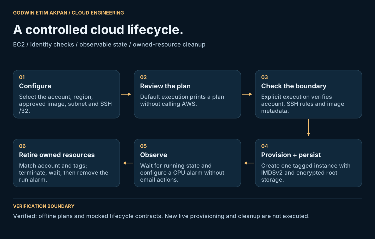
An EC2 lifecycle runner with account checks, restricted SSH, encrypted root storage and ownership-based cleanup.
14 offline tests passed · Historical AWS screenshots preserved.
New AWS execution is pending; offline tests use simulated responses.
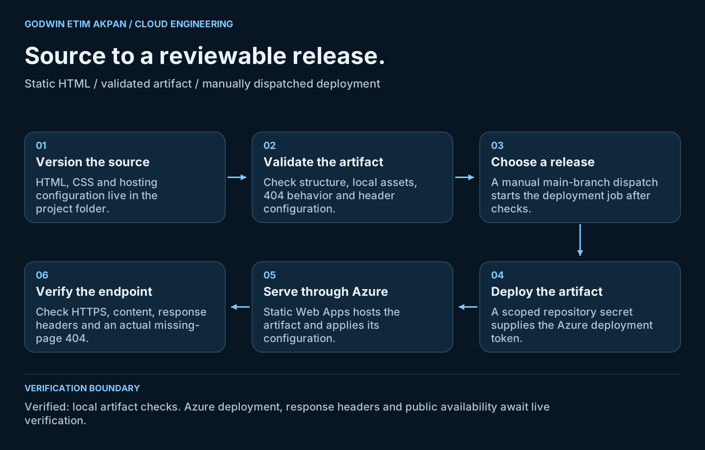
A minimal static application, hosting configuration and deliberate GitHub Actions publishing.
5 artifact checks passed · Source and deployment workflow supplied.
Azure deployment and public endpoint verification remain pending.
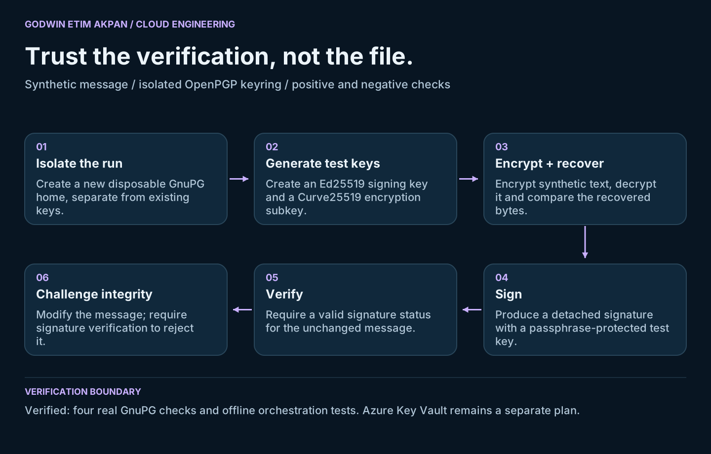
Isolated test keys, encrypted text recovery, detached signatures and a deliberate tamper test.
4 real GnuPG checks passed · 5 offline failure tests passed.
Azure Key Vault is a separate plan; no cloud execution is claimed.
More documented work across Google Cloud, OpenStack, cloud simulation, and distributed processing.
Full cloud & security collectionFrom the data foundation to spatial intelligence—and the platforms that support both.
Build, connect, and validate the data foundation.
Understand patterns, forecast change, and explain results.
Operate the environment and protect the information it serves.
University of East London / UNICAF
Federal University of Technology, Akure / UN-ARCSSTEE
Credentials & development
Esri · Six-week MOOC · Certificate of completion
Credentials & development
Google · Python automation & IT workflows
Credentials & development
Per Scholas · Hands-on security training
Domain-focused professional training
Liberia FETP · NPHIL, U.S. CDC & AFENET · April–December 2023
Applied Epi · 40-hour synchronous course · Certificate of completion
University of Washington · Professional development · 7.5 CEUs
10+ peer-reviewed publications spanning spatial epidemiology, public-health intelligence, and geospatial analysis.
Featured research
MSc dissertation research evaluating predictive performance, spatial intelligence, explainability, security, governance, usability, and decision-support value.
I'm open to professional opportunities and collaborations in data engineering, geospatial engineering, GeoAI, and secure cloud data platforms—especially where reliable data systems support consequential decisions.
godwinea.ai@gmail.com